LOUISVILLE, Ky. – GIS Dynamics, maker of Go iLawn and Go iPave property measuring software, has announced the release of Version 19.4 of its Go iLawn software. Go iLawn 19.4 “Software as a Service” is live and in use by customers.
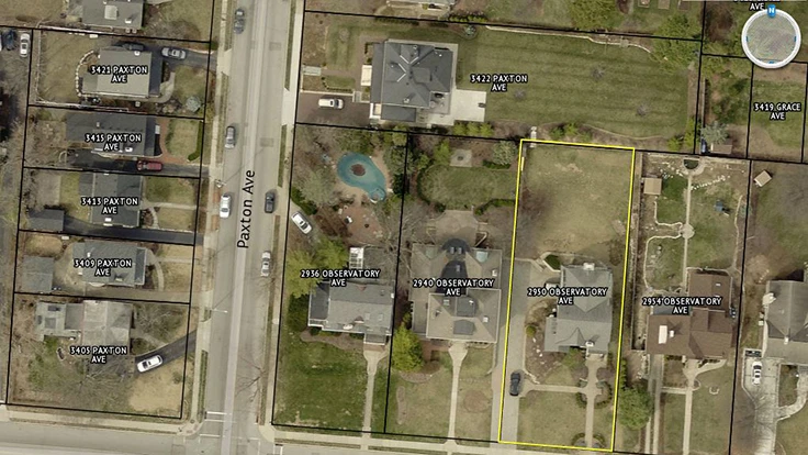
Go iLawn 19.4 provides new tools for better visibility and greater productivity. New features include enhanced image rotation, which lets users see an overhead image from any angle on a 360 degree rotation. Go iLawn 19.4 also introduces new imagery overlays that show streets and parcels across a search area. With only one Go iLawn search, users can see the parcels and addresses across approximately one square mile of area.
Version 19.4 continues Go iLawn’s commitment to providing property measurement tools. Go iLawn has 100 percent coverage across North America and is compatible with Windows 10 and Microsoft’s new Edge browser, as well as Google Chrome and Microsoft Internet Explorer.
Go iLawn 19.4 Updates include:
• 360 degree continuous image rotation
• New overlay of property parcels on map
• New overlay of roads and road names on property map
• Compatible with Windows 10 and Microsoft’s Edge browser
“Our new software release lets users see their worksites better and show them from any angle,” said Mike Rorie, CEO of Go iLawn. “It’s just another way Go iLawn helps you estimate better and gives you great visual tools to sell your work and then go out and execute it.”
For more information, visit www.goilawn.com
Latest from Lawn & Landscape
- SiteOne Landscape Supply acquires Reinders
- Ruppert Landscape acquires Landscapes Unlimited in Wilmington
- Develon unveils -9 Series heavy excavators
- News you might've missed last week
- Lifescape Colorado's Hupf moves to regional role as Ostheimer becomes president
- Your most reliable predictor of success
- LandCare names McCallon, Miller as branch managers
- Takeuchi-US names Paul Wade, Eric Wenzel as dealer development managers